
McNabb Mines
 |
 |
| Company Store | Hotel |
 |
 |
| Two Story Structure | Coke Ovens |
 |
 |
| Rectangular Stone Building | Incline |
Last week I finally bought a new GPS receiver in anticipation of some exploring I planned to do Saturday. I was going to be in Kimball, Tennessee having lunch with some of my cousins, and so I decided to add some nearby waypoints from the National Register of Historical Places. While looking through these places I came across one called McNabb Mines. The Register is a bit sparse as far as details go, but I was intrigued. Google came to the rescue with a link to this article from the Chattanooga Times Free Press. The McNabb Mines was apparently a small mining town built in the early 1880s and abandoned around 1910. This place was supposedly just sitting right there next to a lonely stretch of road along the banks of the Tennessee River and only maybe 20 minutes or so from where I was supposed to eat lunch.
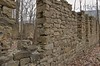
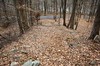
Lunch was nice. Three of my cousins showed up. We ate, and talked, and enjoyed ourselves, then went our separate ways. My GPS guided me along the Tennessee River towards the location that I guessed the most likely location of the mining town. The Times article described its location quite well, but they weren’t handing out latitude and longitude, so my coordinates were a guess. I was a bit worried I wouldn’t be able to find it, but I needn’t have worried. As I rounded a curve at the top of a hill, there right next to the road were the remnants of the old hotel. I drove a bit further looking for someplace to pull off the road and passed the ruins of the old company store. I found a place to pull off the road just a little further down the road.
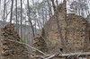
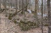
I explored the old hotel and company store, but it wasn’t clear from the article just how much of the original structures were intact. The Historic Register application I found said that there were 76 documented features, but again it wasn’t clear to me how many would turn out to be nothing more than a crumbled ring of stones. Although I was satisfied having explored the hotel and store I walked up the hill towards the general direction of the mines. I found a bit of crumbled foundation and while it wasn’t all that spectacular, I came all this way, may as well take a picture. I climbed a little higher up the hill so I could get a better picture when I noticed some very large walls amongst the trees a bit further up. These walls were much taller than those of the hotel and company store below. So further up the hill I went. I really need to get in better shape.
The Two Story Structure looked as if it were being attacked by trees. There were several lying across it as opposed to growing inside it like the buildings below. This one still had chimneys on two walls and also a tiny bit of plaster on one of the walls.
I wanted to walk further up, but I didn’t have a whole lot of time so I decided to make my way back down. On the way down I found another foundation and another. I didn’t take any pictures of these. A bit further down the road in the opposite direction were the coke ovens and the incline leading to the old mines. The remnants of another stone building were visible from the base of the incline and so I explored it a bit, but the day was getting late and I needed to start heading home.
When I got home and started getting some pictures ready to post on flickr, I reread the PDF and realized I missed at least two other buildings that would have been a lot of fun to explore. There is a church / school building that apparently includes an archway that was still intact as of 2008. Also probably 200 feet away from the “Two Story Structure” was what the archaeologists supposed was the company owners house. Much of it is also supposed to be intact, including 3 fireplaces. And of course, further up the mountain are the mines themselves.
It was a really serene place. I think in the hour or two I was there, three maybe four cars went by. I’ll have to go back sometime and see what else I can find.
Cousins and GPS are Cool, what a fun afternoon.
Are you familiar with abandon coke ovens in or around Tracy City, TN?
When I was a kid visiting cousins in Daus, TN I remember seeing what I was told was an incline
near their house, I have often thought about that incline and its history.
Yeah I’ve heard of the coke ovens at Grundy Lakes, but I’ve not been. Yet. Also the coke ovens in Dunlap. There’s a bunch of old pictures and history about the Dunlap coke ovens here: http://www.cokeovens.com/
The coke ovens at Tracy City are beautiful remnants of the past set against the hills surrounding the Grundy Lake and forest. One could spend a day hiking the trails, picnicing at the number of small parks around the lake. There are wild ferns and flowers just beginning to put on their Spring growth. The park is part of the South Cumberland State Park located between Monteagle and Tracy City. A stop there holds some great exhibits about the coal industry, coke ovens and other points of interest around Tracy City. We in Grundy County and Tracy are lucky to have the park service here. There is a lot of history connected to the ovens. I want to visit the McNabb mines. Great photos. Great site. I found you while researching the Kilgores, Samples, Laynes and Boyds from Grundy County.
I am a descendant of the owners of the McNabb Coke and Coal mines and I have explored some of the ruins, but most of them are just partial structures. I was very happy to see these ruins placed on the National Historic Register. I have driven by them many times and explored some, and I could see these places were not well protected and I worried they would be vandalized or destroyed before too long. Hopefully, they will have a little protection now. The community that grew up around this area was called the Shakerag community. This was because the coal mine workers would go down to the river and use rags to flag down the barges that were to take the coke back up the river. My paternal grandfather actually went to school in the school/church building, but only through the 2nd grade. People didn’t get much in the way of schooling back in the 1800’s. There are many McNabbs still living in this area who could tell you a lot more of the history of the Coke and Coal mines, plus some other interesting stories. Up the road from the ruins is the Pot House. This used to be a weigh station for boats that could not make it any further up the river due to turbulence in the river at that point. The inn/store that used to be there was run by my paternal greatgrandmother’s people, the Browns. There’s also one of the McNabb family cemetaries on that same road (River Canyon Road if you are coming from the Hamilton Co. side or Mullins Cove Road if you are coming from the Marion Co. side.
Thank you so much for the info – I, also have explored the area several times and am always mystified thinking of so long ago – the people, the lifestyle, etc. I am glad you told how the name ‘Shakerag” came about as I couldn’t figure that one out.
I think I’ll take another ride down River Canyon Rd. in the near future and wander around the area once again. It is very peaceful ans so beautiful.
Thanks again,
Nancy J. Card, Owner THE BLIND LADY LLC Hixson, TN.
Always interesting to see items with the name McNabb associated with. I am originally from Maryland . I have no information on my father and I am trying to locate relatives from his side of the family.
Looking for coalminer pics of surname DAGNAN
Thomas Dagnan was a Superintendant of some of the mines. Also Frank Dagnan and John Dagnan were Mining Bosses at the mines in Etna and Montlake in 1800’s and early 1900’s.
I am looking for pics of them or any documents. Thanks!
My g-g-grandfather, Luther “Luke” Hicks lived in in McNabb Mine’s area. He was a miner there. On paper I have him existing in a 1900 & 1910 cenus. He was married to a Rachel Anderson. I have her appearing in 1923 “Around the town” type newspaper article mentioning that she came down from the mines to visit the ferry.
If in any of your research you come across those names, would you please drop me a line? I have spent a unimaginable amounts of time trying to track Luke down.
Thank you!
Sunday Sept 30, 2012. My wife and I walked around there today but did not get up as far as you did or up to the coke ovens. Will be going back when the leaves drop. May make it easier to find some of the the structures. I am a Richie and have been told my great-grand father and back was from the area but I don’t really know who I am related to very well with Richie’s and Ritchie’s on both sides of the River.
I really enjoyed reading this post. I am from Tracy City & am still learning about it and surrounding areas.
Very cool to see things like this with the McNabb name attached to it. I live in Oregon but I am descended from McNabbs from that moved from Carter County in Tennessee before 1900.
I am of direct relation to the owners of McNabb Coke and Coal Mine! I have been learning about my family history for a class project and to stumble across something of this magnitude is astounding!
Is there any info on the Marshalls who once lived in Shakerag? My grandfather Roy Marshall was supposed to have been born in or near there. His father was Frank Marshall. They moved to the Chucky Tn. Area., in or near Greenville Tn. Marshall N.C. was named after my great great grandfather, John Deverous Marshall. Researching my ancestory is exciting and educational. Any info sent my way would be helpful and appreciated!
My mother is a Tennessee McNabb. It’s understandable why our McNabb ancestors chose that USA area coming from Glen Dochart in Perthshire in Scotland. Both have had beautiful landscapes.
My father was a Brown. I’m named after a man my mother married. The McNabb coal company is next to my uncle’s property where I live. Be careful of rattlesnakes. If a sheep dog or boxer shows up please drive a half mile toward the Chattanooga end of Mullins Cove Rd. Stop at my driveway blow your horn and yell Paul. Either myself or my Uncle will come outside. tell us my dogs are down there. Also be careful on Friday and Saturday nights because people are down on down on the river doing drugs. If anyone is looking to find there family members they don’t know go to the Kelly’s ferry community church on Sunday mornings.
My great grandfather Vance (Van) Lowe (1871 – 1933) used to go to Shake Rag to get moonshine during prohibition. My great aunt and great uncle were bootleggers.
My Gibbs ancestors and cousins were miners at Shakerag and several other mines in Franklin and Grundy Counties between 1880 and 1930. Thank you for sharing these treasures of your excursion online!
my name marjorie mcnabb e;;iott my granddad ,curry mcnabb was a coal miner on Etna mtn, we lived along the river on cummings highway in marion co
my other granddad was thomas jefferson sexton they lived along the road where the mcnabb mines were located I have walked that road to visit them
lots of times I am 84 years old